

Geokaun [An Geocan]
Good walks are even better shared.
V3877 : Stone at Geokaun
Steve Edge Photo source
Overview
Geokaun, or An Geocán, is the 266 m highest point of Valentia Island in County Kerry. It is a managed, paid visitor destination with road access to summit-area parking and shorter walks. The Fogher Cliffs viewing deck is a separate feature below the summit.
Geokaun [An Geocán]
Geokaun, or An Geocán, is the 266 m highest point of Valentia Island in County Kerry. It is a managed, paid visitor destination with road access to summit-area parking and shorter walks. The Fogher Cliffs viewing deck is a separate feature below the summit.
Summit and geology
The recorded natural high point is a rock slab about 5 m from the ornamental summit marker. The marker, car park, mast and Fogher Cliffs deck are not substitutes for that recorded high point.
A Royal Irish Academy paper places Geokaun in the Middle Devonian Valentia Slate Formation, containing siltstone and fine sandstone deposited on a floodplain. Later Variscan deformation folded the rocks and developed cleavage. This is formation-level evidence; the exact summit slab has not been separately identified here.
Walking routes
Geokaun visitor loop from the second car park
From the second car park within the paid site, follow the designated visitor loop around the mountain's viewpoints and complete the loop back to the same car park. The Irish Road Trip describes a 1.5 km circuit taking 30–40 minutes, depending on pace; the operator also advertises an approximately 1.5 km loop. These are visitor-circuit figures, not the base-to-summit road ascent. Precise junction geometry and contact with the natural summit slab have not been verified, so follow the current site map and signs. The operator describes the cliff-deck path separately; its 300 m outward distance is not added to this loop. https://www.theirishroadtrip.com/geokaun-mountain-and-fogher-cliffs/ ; https://www.geokaun.com/plan-your-trip
Terrain, views and safety
The main approach is a steep managed road shared by walkers and vehicles. Short visitor trails and viewpoint paths have different scopes; no universal accessibility or all-weather suitability is implied.
In clear weather, viewpoints offer views across Valentia Island towards Dingle Bay, the Skelligs, the Blasket Islands and Kerry's mountains.
Strong winds and hazardous-weather warnings can cause the operator to close the site. Check current entrance notices before entering. There are steep drops near the viewpoints; remain on designated paths and within barriers, and supervise children. Walkers on the steep access road must allow for vehicle traffic. The operator requires dogs to remain on leads.
These are source-based route outlines, not turn-by-turn navigation or a current access or conditions check. Carry appropriate mapping and navigation equipment.
Access and facilities
The operator lists four car parks within the paid Geokaun site at Feaghmaan West, Valentia Island, including summit-area parking. This is not a trailhead car park in Portmagee. Check the operator's current admission conditions and closure notices before travelling: https://www.geokaun.com/plan-your-trip
The operator advertises picnic tables, information panels and a small shop with toilets that open only during the summer shop season. Do not rely on toilets or refreshments outside that season. Admission is charged for foot and vehicle entry; current charges and conditions should be checked with the operator.
A current trailhead public-transport service and last return have not been verified; check before travelling.
Name and history
Paul Tempan records An Geocán and the alternative name Feaghmaan Mountain, but treats the name's origin as obscure. Suggested meanings and a possible pole or mast connection remain hypotheses; the small-yew-tree translation is unsupported.
The Valentia Slate study traces commercial quarrying at Dohilla on the mountain's slope from 1816. An Irish Times interview in 2008 documents development of the visitor road, paths and viewpoint parking by that time; it does not establish an exact opening year or current ownership.
Explore routes near Geokaun [An Geocan]
Walks starting near this hill. Open a route to check its map, distance and full itinerary.
Route planning notes
These notes describe possible approaches. Check a route's map and access information when planning your walk.
Geokaun visitor loop from the second car park
From the second car park within the paid site, follow the designated visitor loop around the mountain's viewpoints and complete the loop back to the same car park. The Irish Road Trip describes a 1.5 km circuit taking 30–40 minutes, depending on pace; the operator also advertises an approximately 1.5 km loop. These are visitor-circuit figures, not the base-to-summit road ascent. Precise junction geometry and contact with the natural summit slab have not been verified, so follow the current site map and signs. The operator describes the cliff-deck path separately; its 300 m outward distance is not added to this loop. https://www.theirishroadtrip.com/geokaun-mountain-and-fogher-cliffs/ ; https://www.geokaun.com/plan-your-trip
Make a day of it, together
Find someone to share the walk with, or organise a day out along a route you like.
Photo Gallery
View all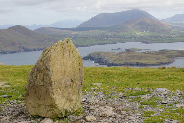 Photo could not load
V3877 : Stone at Geokaun
Steve Edge
Hill facts and local notes
Classifications
Elevation
266m
873 ft
Prominence
266m
Coordinates
51.9227, -10.3463
V386770
OS Map
83
At the Summit
The recorded natural high point is a rock slab about 5 m from the ornamental summit marker. The marker, car park, mast and Fogher Cliffs deck are not substitutes for that recorded high point.
Terrain & Geology
A Royal Irish Academy paper places Geokaun in the Middle Devonian Valentia Slate Formation, containing siltstone and fine sandstone deposited on a floodplain. Later Variscan deformation folded the rocks and developed cleavage. This is formation-level evidence; the exact summit slab has not been separately identified here.
Views & Scenery
In clear weather, viewpoints offer views across Valentia Island towards Dingle Bay, the Skelligs, the Blasket Islands and Kerry's mountains.
History & Heritage
Name Origin
Paul Tempan records An Geocán and the alternative name Feaghmaan Mountain, but treats the name's origin as obscure. Suggested meanings and a possible pole or mast connection remain hypotheses; the small-yew-tree translation is unsupported.
Historical Significance
The Valentia Slate study traces commercial quarrying at Dohilla on the mountain's slope from 1816. An Irish Times interview in 2008 documents development of the visitor road, paths and viewpoint parking by that time; it does not establish an exact opening year or current ownership.
Getting There & Facilities
Parking
The operator lists four car parks within the paid Geokaun site at Feaghmaan West, Valentia Island, including summit-area parking. This is not a trailhead car park in Portmagee. Check the operator's current admission conditions and closure notices before travelling: https://www.geokaun.com/plan-your-trip
Nearby Facilities
The operator advertises picnic tables, information panels and a small shop with toilets that open only during the summer shop season. Do not rely on toilets or refreshments outside that season. Admission is charged for foot and vehicle entry; current charges and conditions should be checked with the operator.
Safety Information
Known Hazards
- Strong winds and hazardous-weather warnings can cause the operator to close the site. Check current entrance notices before entering.
- There are steep drops near the viewpoints; remain on designated paths and within barriers, and supervise children.
- Walkers on the steep access road must allow for vehicle traffic.
- The operator requires dogs to remain on leads.
General Safety Tips
- Check weather conditions before setting out
- Carry appropriate clothing and equipment
- Let someone know your planned route
- Take a map, compass, and GPS device
- Carry emergency supplies: food, water, first aid kit, torch
Hills
Some common questions about the hills answered
Are there group walks up Geokaun [An Geocan]?
Many walkers use Walkmates to join or organise walks with others. You can check for group walks around Geokaun [An Geocan] through the maps
Are there other walkers around Geokaun [An Geocan]?
Activity varies by location and time, but Walkmates lets you see whether others have shared walks or shown interest in this area. Find other people through the walking friends search walking friends for Geokaun [An Geocan] search or of course create your own walk for Geokaun [An Geocan]
Can I organise a walk to Geokaun [An Geocan]?
Yes. If there aren’t any walks listed already, you can create a walk and make it available for others to join.
If you're signed up to Walkmates, you can create a walk to Geokaun [An Geocan].
How do I find a walk up this hill?
There are often multiple ways to walk this hill, depending on experience and route preference. Walkmates helps you explore walks and routes that others have shared.
Can I suggest a new route up Geokaun [An Geocan]?
Yes. You can suggest or create routes to share with others. Walkmates focuses on the social side of walking, so routes are used to help people organise walks and explore areas together, rather than as detailed navigation tools or route libraries.
Other uses really appreciate knowledgeable walkers sharing their routes. Share your favourite route to Geokaun [An Geocan] here
The is an error or something incorrect about this hill. How do I let you know?
We always strive to keep the information on Walkmates as accurate as possible. If you find an error, please let us know through the contact form and we'll aim to correct it as quickly as possible
Community Discussion
Comments
Location
![Geokaun [An Geocan] location map](https://cdn.walkmates.com/hill-maps/hill-sources/20508/51.92274_-10.34633.png)
Grid reference: V386770
View on OpenStreetMapOpens a map in a new tab, centred on the hill.
No comments yet. Be the first.